


The text is from here.
Minamikouchi, Kawamukai-cho area
Last updated on October 16, 2023.
Notice
・We announced the dissolution approval of the Kawamukai-cho Minamikochi District Land Readjustment Association. (July 25, 2023)
Current status of the district
The Kawamukai-cho Minamikochi area is located in the urbanization control area in the southern part of Tsuzuki Ward . Within the area, the high-speed Yokohama Loop Northwest Line and the Kawamukai Line are defined as crossing the area, adjacent to the Kohoku Interchange.
In the Yokohama Medium-Term Four-Year Plan 2014-2017, the main initiatives for the development of compact and vibrant suburban areas include large-scale land use conversion in urban areas and the use of former base sites, as well as infrastructure development around railway stations and interchanges, while balancing with the creation of a favorable green environment with conservation. In addition, the Tsuzuki Ward Plan of the Yokohama City Urban Planning Master Plan states that the Kawamukai district (the area around the Kohoku interchange) will promote strategic land use in accordance with regional characteristics, such as attracting and accumulating industries that take advantage of the convenience of transportation.
In this district, based on such a policy on town development, the land readjustment preparation union in Kawamukai-cho Minamikochi district was established by landowners in July 2014, and proceeded with the examination of town development with Motoichi, and in March 2018 The city planning procedure was started, and "Transfer to urbanization areas" and "Land readjustment project" by union enforcement were decided, and on the same day, the "Gyokawa Mukaimachi Minamikomachi Minamiko Land Readjustment Project" was established land readjustment project" was established.
After that, on July 3, 2020, the "Kawamukai-cho Minamikochi District District Plan" was decided, and the infrastructure maintenance work was completed in March 2022.
On January 12, 2023, the landfill disposal was announced, and in July of the same year, the union dissolution was approved.
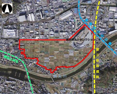
(Effective Area Map)
Overview of Business
| Business name | Land readjustment project for Minamikochi district in Kawamukai-cho |
|---|---|
| Constructor | Kawamukai-cho Minamikochi District Land Readjustment Association |
| Enforcement area | Part of Kawamukai-cho, Tsuzuki-ku and part of Higashigatacho |
| Enforced area | Approx. 18.2ha |
| Effective period | From March 23, 2018 to July 25, 2023 |
| Total operating expenses | Approx. ¥5 billion |
| Public facilities plan | Maintenance of divided roads (width: 4.5m to 13.5m) Maintenance of parks, maintenance of regulating ponds |
※The plan may be revised depending on the progress of the business.
※For details, please see this page (PDF: 435KB).
District planning system
Click to move to the plan / plan map.
You may need a separate PDF reader to open a PDF file.
If you do not have it, you can download it free of charge from Adobe.
![]() To download Adobe Acrobat Reader DC
To download Adobe Acrobat Reader DC
Inquiries to this page
Urban Development Promotion Division, Urban Development Bureau Urban Development Department
Phone: 045-671-4009
Phone: 045-671-4009
Fax: 045-664-7694
E-Mail address [email protected]
Page ID: 924-320-656


