Higashi Totsuka Station - British Commonwealth Cemetery Route (distance: about 3.7 km, travel time: about 55 minutes)
Walking route introduction
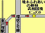
Musou State Border Monument
| Cumulative distance: approximately 1.3 km, travel time: approximately 20 minutes
Musou border monument. This was the border between Musashi and Sagami in the past. Behind this is the Sakaigi guardian of children and travelers and the Sakaigi Fureai Forest.
|  |
|---|

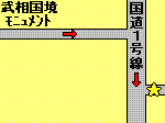
Tunnel leading to elementary school student Amusement Park
| Cumulative distance: approximately 2.2 km, travel time: approximately 33 minutes
From the Musou Koku border monument, go down the slope of a residential area and cross National Route 1, and go through this tunnel. National Route 1 has a lot of traffic, so let's walk carefully.
|  |
|---|
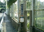
Stairs leading to the elementary school student Amusement Park
| Cumulative distance: approximately 2.5 km, travel time: approximately 37 minutes
After passing through the first tunnel, go down this staircase on your right. Go down the stairs to the elementary school student Amusement Park.
|  |
|---|

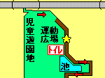
elementary school student Amusement Park
| Cumulative distance: approximately 2.6 km, travel time: approximately 38 minutes
The path behind the elementary school student Amusement Park is rich in nature and you can walk very comfortably. The toilet is located between the sports square and the pond on the right side of the direction of travel.
|  |
|---|

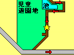
elementary school student Amusement Park
| Cumulative distance: approximately 3.0 km, travel time: approximately 46 minutes
Go along the path while looking at the pond to your right.
|  |
|---|

The road leading to the Commonwealth Cemetery
| Cumulative distance: approximately 3.2 km, travel time: approximately 48 minutes
After passing through elementary school student Amusement Park, turn left and head to the Commonwealth Cemetery. The slope is a bit tight, but it's just a little more to the goal.
|  |
|---|

Commonwealth Cemetery
| Cumulative distance: approximately 3.7 km, travel time: approximately 55 minutes
The goal is a very beautiful British Commonwealth graveyard. Thank you very much.
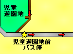
elementary school student Amusement Park (Yokohama-sta.-nishiguchi / Hodogaya Station East Exit, Heiwadai Turnaround, and Nihon-odori-sta.-kencho-mae / Kannai-sta.-kitaguchi)
|  |
|---|