


- Yokohama-shi Top Page
- Tsurumi Ward Top Page
- Introduction of the ward
- Overview of Tsurumi Ward
- Booklet "Tsurumi, this town, this person"
- Natural Environment and Landscape of Tsurumi
The text is from here.
Natural Environment and Landscape of Tsurumi
Last updated on January 24, 2019.
※The contents of the publication are excerpted from the booklet “Tsurumiko Town Konoto” published in March 1999. This booklet was edited by the "Tsurumiko Town Kono People" editorial committee by inhabitants of a ward, and the "Iimachi Tsurumi Movement Promotion Committee" issued it. .
Therefore, please note that the content may differ from the current one.

<Photo shows Shishigaya Citizen's Forest and Babbling Small Path>
Tsurumi Ward is located in the northeastern part of Yokohama City, adjacent to Kawasaki City to the north and east, Kanagawa Ward to the west and Kohoku Ward to the northwest.
In the ward, the only first-class river in Yokohama, Tsurumi River, flows meandering from north to south and pours into Tokyo Bay. Topographically, it is divided into three areas: hills in the northwest, lowlands in the Tsurumi River basin, and landfills in the coastal area.
In this way, Tsurumi has a variety of terrain with mountains, seas, and rivers. The climate is generally warm, and the natural environment and landscape are very blessed.
From Tsurumi Station, take the JR Line and look on the right side on the way toward Yokohama, and the plateau spreads in front of you. This plateau is 40-50m high and extends to the northwest Shishigaya citizen forest.
When you climb the hill in the ward and look around, you can see that the plateau is very undulating, and that several small Tandos are entering the ridge.
Until the middle of the Showa era, Tando was paddy fields and hills were rural areas of forests and fields, but now it has been developed as residential land except for some areas, and is a residential area with many slopes.
The forest of Shishigaya citizens in the north, Mitsuike Park in the prefectural area, the Higashiterao contact forest in the west, and the Sojiji Temple in the south are still covered with greenery and are a place for residents to relax.
About 6,000 years ago, the area around the plateau except the plateau was covered by the sea (Kotama Bay). As a result, sand and mud were deposited on the seabed, and then landed by the retreat, resulting in flat land. The Tama River and Tsurumi River flow through this area, creating a delta plain downstream from Kashimada in Kawasaki City.
A wide arterial road called the Tsurumi Mizonoguchi Line runs north and south through this lowland, and offices, shops, and houses are lined up across the road, showing a different landscape from the hill area.
The area surrounded by the Tsurumi River, which is curved by the railway, is the largest business district in the ward, with many high-rise buildings, including the ward office and police department, along the national highway.

<Photo shows commuting scenery of East Exit Tsurumi Station>
The map created in 1882 (1882) shows that most of the current coastal industrial zones were seas. In the Taisho era, large-scale landfill construction began to create an industrial area.
This landfill project is carried out over the Taisho, Showa and Heisei eras, and the landfill area accounts for about one-third of the total area of Tsurumi Ward. The current Anzencho 1.2-chome, Suehirocho 1.2-chome, Daikoku-cho, and Daikoku-futo correspond to this, and most landfills are factories, wharfs, and distribution-related warehouses.
However, in recent years, citizen-use facilities such as "Fureyu" and "Umizuri Park" have been established, greening has been promoted, and it has become a new face of Tsurumi.

<The photo shows Tsurumi River Iron Bridge in Keikyu, which was hit by a flood (near the Tsurumi River Iron Bridge)>
The Tsurumi River is a 42.5km long river with headwater in the mountains of the Tama Hills. The river flows winding and the slope is gentle, so every time heavy rain falls, floods have been repeated downstream, so it has long been called the "Range River".
People in the basin have been threatened by their lives and lives since the Edo period. Every time a flood occurred, houses and fields were flooded, and bridges and embankments were washed away. If the villagers worked together to build dike to protect their lives and livelihoods, it was a cause of conflict with villages on the opposite bank and upstream.
As the times progressed, it was hit by a flood in September 1958. According to the Kanagawa Shimbun-sha, "The Kano River Typhoon flooded the Tsurumi River, flooded the fields in a short time, and the coastal private houses died to the roof. Komaoka and Sueyoshi. Tsukudano, Ichibashimocho, Sugasawa and Sakaemachi-dori are the worst, with 2,700 flood above floor level houses, of which hundreds of them died to the eaves of their houses.
In this way, the Tsurumi River was a flood and flood control work, and in the basin it was repeated struggles with villagers.
While it is said to be a rampage river, the river has brought rich blessings. Due to the gentle flow of the river, boat transportation was thriving until the end of the Taisho era, and the river line was said to have been quite busy.
There was a red brick manufacturing plant near Sueyoshi and Yako, and at that time there was considerable demand for building materials, so heavy bricks were transported by boat. In rural areas, manure was transported by fertilizer ship and wood were transported, and sawmills were built downstream, which was very booming.
At that time, the Tsurumi River was clean, unlike now, and until the beginning of Showa, it was a great water playground for children.
According to a newspaper report, the Tsurumi River has become one of the worst ranks of dirty rivers. With the urbanization of the basin, factories and domestic wastewater are said to be the cause.
The movement to make this Tsurumi River a friendly river has been occurring for a long time. One of them is the Tsurumi River Raft Festival, which began in August 1988. Today, the Tsurumi Ward fireworks festival is also held on the night of the day, and is crowded with tens of thousands of people.
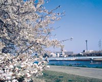
In addition, the number of people who are familiar with the river and engage in environmental conservation, such as the Association to Make the Tsurumi River Fun and the Association to Rediscover the Tsurumi River, has increased interest in the Tsurumi River by planting cherry trees along the dike.
The Tsurumi River is a place of peace for our inhabitants throughout the four seasons. We want you to clean this river as much as possible and use it as a relaxing space for inhabitants of a ward.
Inquiries to this page
Tsurumi Ward General Affairs Department Ward Administration Promotion Division
Phone: 045-510-1680
Phone: 045-510-1680
Fax: 045-510-1891
E-Mail address [email protected]
Page ID: 429-199-090


