


- Yokohama-shi Top Page
- Living, procedures
- Community Development and Environment
- Roads
- Construction
- Urban planning roads
- In-business routes
- Katsuracho Tozuka Endo Line (Kami Kurata Tozuka area)
The text is from here.
Katsuracho Tozuka Endo Line (Kami Kurata Tozuka area)
Last updated on April 1, 2025.
The city planning road Katsuracho Tozuka Endo Line is a 10,240m urban planning road that starts at Katsuracho, Sakae-ku (Ring Route 4) and ends at Shimo-Iida-cho, Izumi-ku (Fujisawa-shi border). Of these, the Kami Kurata Tozuka area is a 990m section from Kamikurata-cho (Shimonagaya Ofuna Line) in Totsuka-cho (National Route 1) in Totsuka-ku, and has been operating since July 1995. .
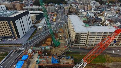
Currently, we are mainly engaged in construction and land acquisition around Takashimabashi Bridge.
| Progress and future announcements of the replacement of Takashimabashi Bridge | |
|---|---|
◆I would like to inform you about the current progress and future prospects of the replacement of Takashimabashi Bridge. |
| Notice of traffic regulation accompanying the removal of the Moritokuji Overpass (Yokohama Driving School side city road) | |
|---|---|
◆On the removal of pillars and large cranes associated with the removal of the Moritokuji Overpass, traffic restrictions (partially closed) will be imposed on the city road on the Yokohama Driving School side. |
| Business district | Katsuracho Tozuka Endo Line (Kami Kurata Tozuka area) |
|---|---|
| Section | Kamikurata-cho, Totsuka-ku (Shimonagaya Ofuna Line)-Totsukamachi (National Route 1) |
| Fiscal year | 1995-1997 |
| Scale | Extension 990m, width 22-33m |
| Maintenance effect | ◆Strengthening transportation functions |
| Land acquisition rate※ | 77% (estimated as of the end of FY2024) |
| Business progress rate※ | 46% (FY2024 forecast) |
| Current construction Contract details | ◆Urban planning road Katsuracho Tozuka Endo Line (Kamikurata Tozuka area) Street maintenance work (No. 3 construction zone No. 29) |
| Related information | ◆You can look at administrative map information such as city planning from Yokohama-shi administrative map information system (outside site). |
※The land acquisition rate shows the ratio of the acquired area among the areas that have been approved for business.
※The business progress rate is shown as the execution rate of total operating expenses.
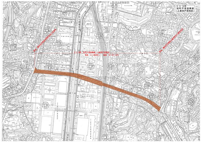
Location map
 View National Route 1 from the Kashio River (February 2023)
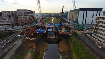 Replacement of Takashimabashi Bridge (February 2023)
You may need a separate PDF reader to open a PDF file.
If you do not have it, you can download it free of charge from Adobe.
![]() To download Adobe Acrobat Reader DC
To download Adobe Acrobat Reader DC
Inquiries to this page
Construction Division, Construction Department, Road and Highway Bureau Construction Department
Phone: 045-671-3521
Phone: 045-671-3521
Fax: 045-663-8993
E-Mail address [email protected]
Page ID: 449-757-230


