


The text is from here.
Nagata Hirato Tanikawa
Last updated on March 23, 2021.
Hirato Nagatanikawa originates near Noba-cho, Konan-ku, flows almost parallel to Route 2, joins the Akuwa River in Kashiocho, Totsuka-ku, and forms the Kashio River.
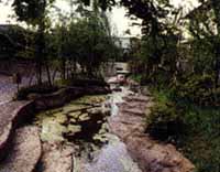
Green is seen only in the middle stream, but as it flows through the urban areas of Konan Ward and Totsuka Ward, it is a river with little green overall.
Upstream, there is a main road from Loop Route 2 to Kaminagaya Station on the Municipal Subway, Nagatani Tenmangu Shrine to the south and a small forest that is a green landmark.
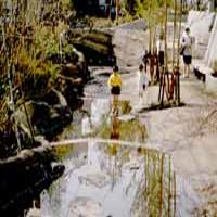
Renovation was started in 1970, and the planned renovation extension is 4.92 km from the junction of Akuwa River to Morai Bridge. The river line of about 1.5 km from the middle cat bridge to the upstream is maintained, and upstream from Yanagibashi flows along Loop Route 2.
Introduction of waterside
Waterside of Kaminagaya Fureai
Along with the renovation plan, the park was constructed as a babbling promenade between Temma Miyashita and Yanagibashi, a part of the old riverbed that disappeared. The park is divided in some places by roads that go to Loop Route 2, such as Ipponbashi, but it is popular as a relaxing space on Loop Route 2, which has a lot of traffic.
Data
| Management category | Sakaigawa River System Second Class River |
|---|---|
| Management extension | 4,920m |
Inquiries to this page
River Planning Division, Sewerage and Rivers Bureau River Department
Phone: 045-671-4215
Phone: 045-671-4215
Fax: 045-651-0715
E-Mail address [email protected]
Page ID: 778-416-428


