


The text is from here.
Maioka River
Last updated on March 23, 2021.
The Maioka River flows almost northwest from the vicinity of Maioka-cho, Totsuka-ku, and joins the Kashio River in Kashiwao-cho, Totsuka-ku.
The headwater area is around Maioka Park. It is designated as an urbanization adjustment area from upstream to midstream, and fields are cultivated along Tando. The hills are urbanized, but there are many green spaces on the slopes. There is also the subway Maioka Station in the center of the basin, and the downstream is the old city area along National Route 1.
The total length of about 1.64 km from the junction with the Kashio River to the junction of the right tributary is the Urban Ogawa River Rehabilitation Project (currently shifted to the Urban Infrastructure River Rehabilitation Project) We're making improvements.
Introduction of waterside
Maioka River Fureai Plaza
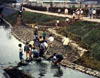
The waterfront plaza was constructed using the river management passage adjacent to Maioka Elementary School and the former riverbed. The schoolyard and the waterfront plaza were not separated by fences, and stairs were set up to the river with the banks of the river gently, and spaces for playing on the riverbank and wooden passages were set up. In addition, the main pillars and railings of bronze Indian spot-billed duck were set up on the Maioka Karugamo Bridge in front of the school gate.
Data
| Management category | Sakaigawa River System Second Class River |
|---|---|
| Management extension | 1,640m |
Inquiries to this page
River Basin Coordination Division, Sewerage and Rivers Bureau River Department
Phone: 045-671-4215
Phone: 045-671-4215
Fax: 045-651-0715
E-Mail address [email protected]
Page ID: 835-987-663


