- Yokohama-shi Top Page
- Naka Ward Top Page
- Disaster Prevention and anti-crime program
- Disaster Prevention and Disasters
- Map of disaster prevention
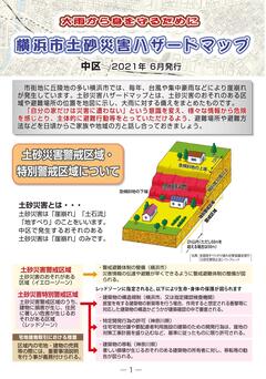
- landslide hazard map (a region where there is a possibility of landslide)
The text is from here.
landslide hazard map (a region where there is a possibility of landslide)
Last updated on August 15, 2024.
This map allows you to check the locations designated by Kanagawa Prefecture as "landslide warning Area, etc."
This refers to areas that may be damaged in the event of landslide due to heavy rains caused by torrential rainfalls and typhoons.
Click here for confirmation from the Internet
For the latest designation status and detailed maps, please refer to the "Area where there is a risk of landslide" on the sediment disaster information Portal in Kanagawa Prefecture or contact the Yokohama Kawasaki Flood Control Office in Kanagawa Prefecture.
Click here to download the map issued by Yokohama City.
You can download the same thing issued by Yokohama City on paper from here. The information on this page is current as of the time of creation of hazard map.
Published in June 2021
- landslide hazard map (Naka Ward) Map surface (PDF: 3,755KB)
- landslide hazard map (Naka Ward) Information page (PDF: 2,784KB)

Distribution of paper maps
The same thing that can be downloaded is distributed at General Affairs Division Naka Ward Office.
You may need a separate PDF reader to open a PDF file.
If you do not have it, you can download it free of charge from Adobe.
![]() To download Adobe Acrobat Reader DC
To download Adobe Acrobat Reader DC
Inquiries to this page
Naka Ward General Affairs Department General Affairs Division
Phone: 045-224-8112
Phone: 045-224-8112
Fax: 045-224-8109
E-Mail address [email protected]
Page ID: 525-147-407


