


- Yokohama-shi Top Page
- Konan Ward Top Page
- Disaster Prevention and anti-crime program
- Disaster Prevention and Disasters
- Disaster prevention map, hazard map, etc.
The text is from here.
Disaster prevention map, hazard map, etc.
Disaster prevention maps and various types of hazard map are distributed at Public Relations Section on the first floor of the Konan Ward Office and General Affairs Division on the fifth floor.
Last updated on January 22, 2025.
Konan Ward Disaster Prevention Map (issued in March 2023)
You can check disaster prevention bases in the ward, evacuation area, and evacuation sites during storm and flood damage.
Konan Ward Residents' Life and Disaster Prevention Map
◆About water station at the time of disaster
You can find a disaster water station near your home in earthquake disaster.
Locationsma "Disaster Water Station in Yokohama City" Map
Water stations during disasters
Konan Ward hazard map (landslide, Flood, Inland Water, high tides)
In hazard map, you can check areas where there is a risk of flooding caused by landslide, floods, inland waters and high tides.
landslide hazard map (issued in March 2024)
Map surface (PDF: 4,240KB)
Overview (PDF: 2,928KB)
Konan Ward designated landslide Special warned area and landslide warning Areas for the Collapse of steep slope on February 5, 2021.
For legal drawings such as notification books, please refer to the following Kanagawa Prefecture website for "Area where there is a risk of landslide" or contact the Yokohama Kawasaki Flood Control Office in Kanagawa Prefecture.
Kanagawa sediment disaster information Portal (outside site) Links to Kanagawa homepage.
Inundated hazard map (October 2024)
Inland water and flood hazard map (PDF: 10,266KB)
high tides hazard map Information (PDF: 6,720KB)
Other confirmation methods
The areas of hazard map above are:
- Yokohama-shi administrative map reporting system "Wai Wai disaster prevention map" (outside site)
- Yokohama City Disaster Prevention App "Yokohama City Evacuation Navigation"
But you can check it.
If it is difficult to see on the scale of hazard map, please use this too.
The "Wai Wai Disaster Prevention Map" allows you to search from Address, and the Yokohama City Evacuation Navi allows you to check the map from your current location.
In addition, please refer to the following for explanation of flood damage hazard map concerning flood control law.
・Explanation on the Flood Control Law (explanation of important matters, etc.)
Immediate Areas subject to evacuation warning
What is the immediate evacuation warning area?
Based on the lessons learned from Typhoon No. 18 in October 2014, Yokohama decided to extract cliffs that could cause significant damage to houses in the event of a landslide, and to issue the evacuation warning (landslide alert informationevacuation warning immediately) to the surrounding area.
For details, please refer to the following page of City of Yokohama, General Affairs Bureau Crisis Management Division (listed at the bottom of the linked page).
City of Yokohama, General Affairs Bureau Crisis Management Division Page
About the immediate evacuation warning area within Konan Ward
There are five immediate evacuation warning areas in Konan Ward. (As of May 2021)
※Target households are notified every year that they are the target area.
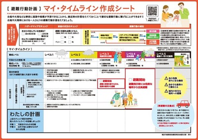
My timeline
↵
My Timeline is a self-evacuation action plan that has been organized in chronological order in advance according to the family structure and local environment of each person in response to disasters that may occur in the future, such as typhoons and heavy rains.
Once you have identified a dangerous place in hazard map, prepare a sheet to create your own My Timeline.
※My Timeline can also be created on the disaster prevention application "Yokohama City Evacuation Navi".
Download and create My Timeline Creation Sheet Video Page
You may need a separate PDF reader to open a PDF file.
If you do not have it, you can download it free of charge from Adobe.
![]() To download Adobe Acrobat Reader DC
To download Adobe Acrobat Reader DC
Inquiries to this page
Konan Ward General Affairs Department General Affairs Division General Affairs Section in charge of crisis management and regional disaster prevention
Phone: 045-847-8315
Phone: 045-847-8315
Fax: 045-841-7030
Page ID: 248-094-296


